Zoning plan of České Budějovice – Urban Planning Concept
České Budějovice, as a major center of the South Bohemian region, is striving to become a resilient and attractive metropolis. This concept outlines a realistic path toward sustainable growth and the gradual transformation of the city over the coming decades. The main goal is to create a high-quality and beautiful environment capable of accommodating up to 135,000 residents in the future.
Based on eight fundamental ambitions, this concept, with its level of detail, goes beyond the scope of a typical zoning plan. It offers local government and the public a clear guide for future development that responds to both political mandates and in-depth expert discussions. It operates on four scales—from a strategic metropolitan vision through the city as a whole to detailed regulations for specific locations.
| Project name: | Zoning plan of České Budějovice |
| Creative teams: | Pavel Hnilička Architects+Planners (CZ), Studio MAP (CZ), Omgeving (BE), Mott MacDonald (CZ), Studio Relinkt (CZ) |
| Authors - PHAP: | Pavel Hnilička, Jan Pačka, Lucie Leňo Cutáková, Mikuláš Valdman, Veronika Žďárská, Linda Skřivánková |
| Authors - Studio MAP: | Jan Šíma, Pavel Vojtko |
| Authors - OMGEVING: | Peter Swyngedauw, Daphne Roels, Simona Reiciunaite, Natalia Pawlowska, Evi Peeters |
| Authors - Mott MacDonald: | Daniel Šesták, Ondřej Kokeš |
| Authors - Studio Relinkt: | Marek Kratochvíl, Wouter Verleure |
| Other authors: | Štepán Špoula |
| Client: | The city of České Budějovice |
| Year: | 2026 |
A DEVELOPING CITY
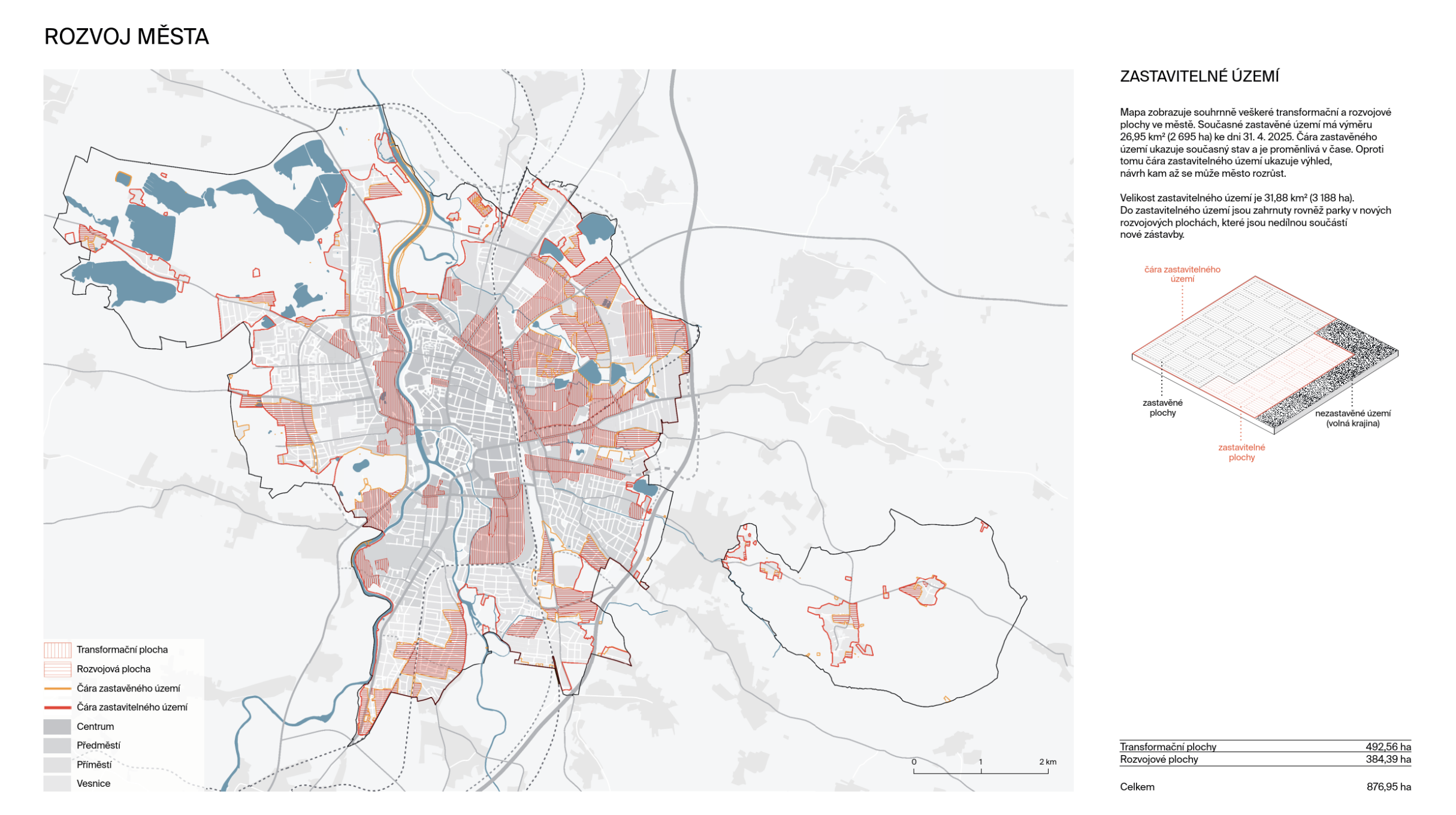
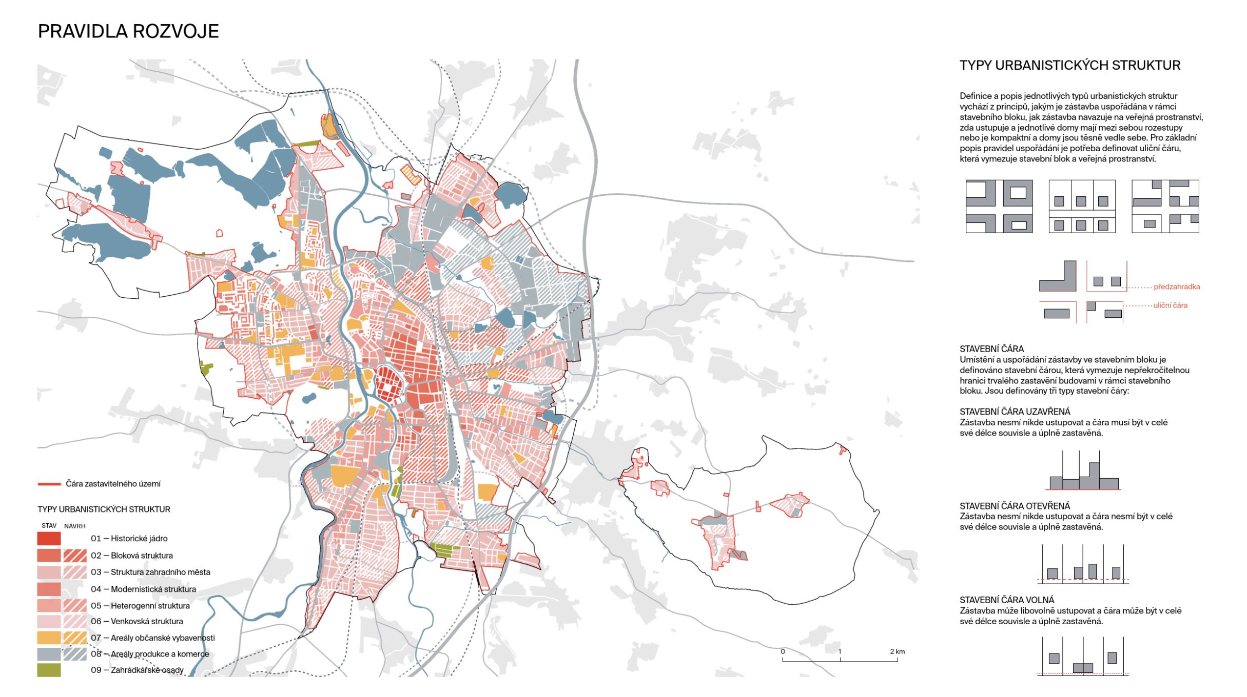
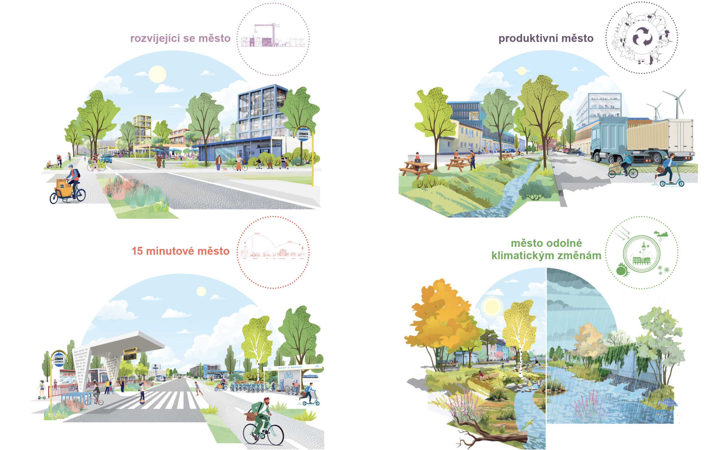
The development priority is the transformation of existing neighborhoods and brownfields rather than expanding the city into open countryside. The renovation of outdated buildings and the sensitive expansion of the built environment must aim for multifunctional use while preserving the identity of the place. New construction is permitted only in strategic locations, with an emphasis on a compact structure that reduces dependence on cars. The key is high-quality public spaces, climate resilience, greenery, and the concurrent development of civic amenities.
PRODUCTIVE CITY
České Budějovice must support existing and new economic activities with an emphasis on technology and innovation. Industrial sites need to be transformed into sustainable and pleasant workplaces with ample greenery, good bicycle accessibility, and renewable energy sources. We will achieve greater efficiency by revitalizing neglected areas and sharing infrastructure—for example, by building shared parking garages, sharing loading zones, or placing ancillary functions (offices, dining) on building rooftops.
THE 15-MINUTE CITY
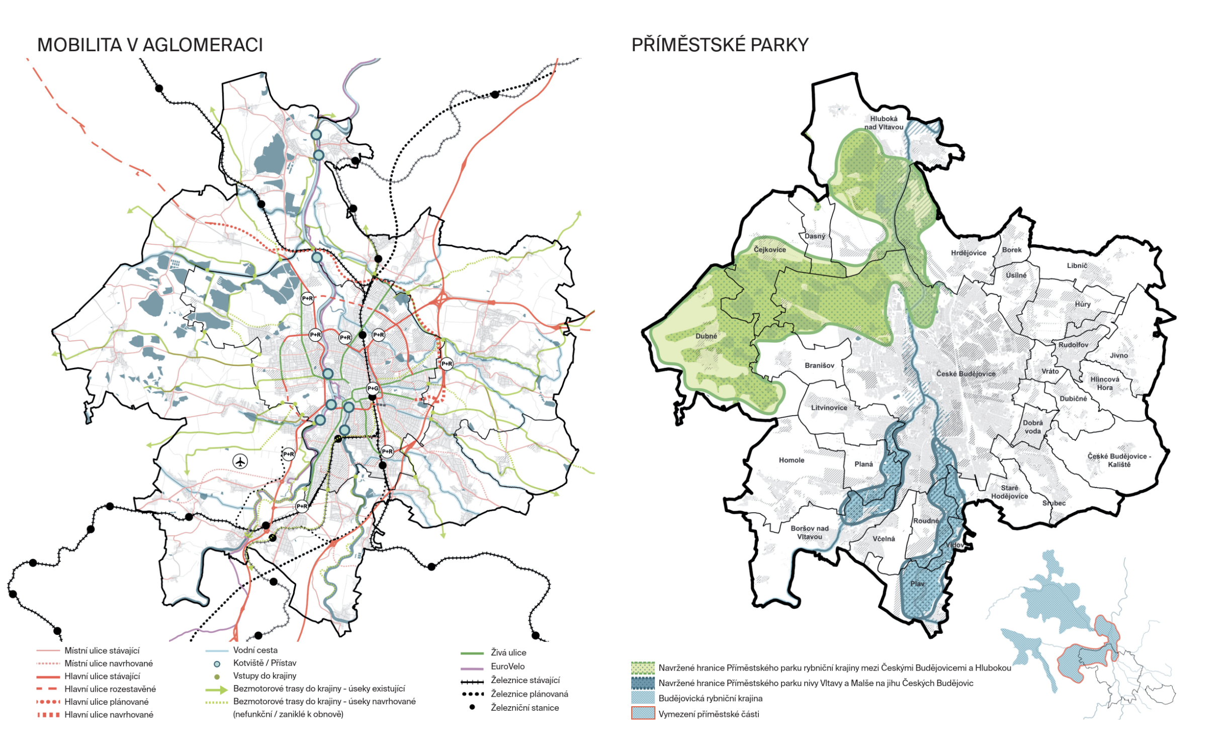
We advocate the concept of the “15-minute city,” based on a compact structure and a high-quality network of slow transport. Public transport must be more capacious and accessible, supplemented by multimodal hubs for easy sharing of cars, bicycles, and scooters. The priority is to transform streets so that car traffic no longer dominates public space but becomes a complement to safe, active mobility.
A CLIMATE-RESILIENT CITY
Adapting to climate change requires the creation of a continuous system of blue-green infrastructure. Water bodies and green spaces must permeate the entire city, cooling it and ensuring water retention. In flood zones, new development must be prohibited, and riverbanks must remain permeable. This system is complemented by energy-efficient buildings that utilize renewable energy sources, such as solar panels on the roofs of large halls.
A CITY THAT SUPPORTS BIODIVERSITY
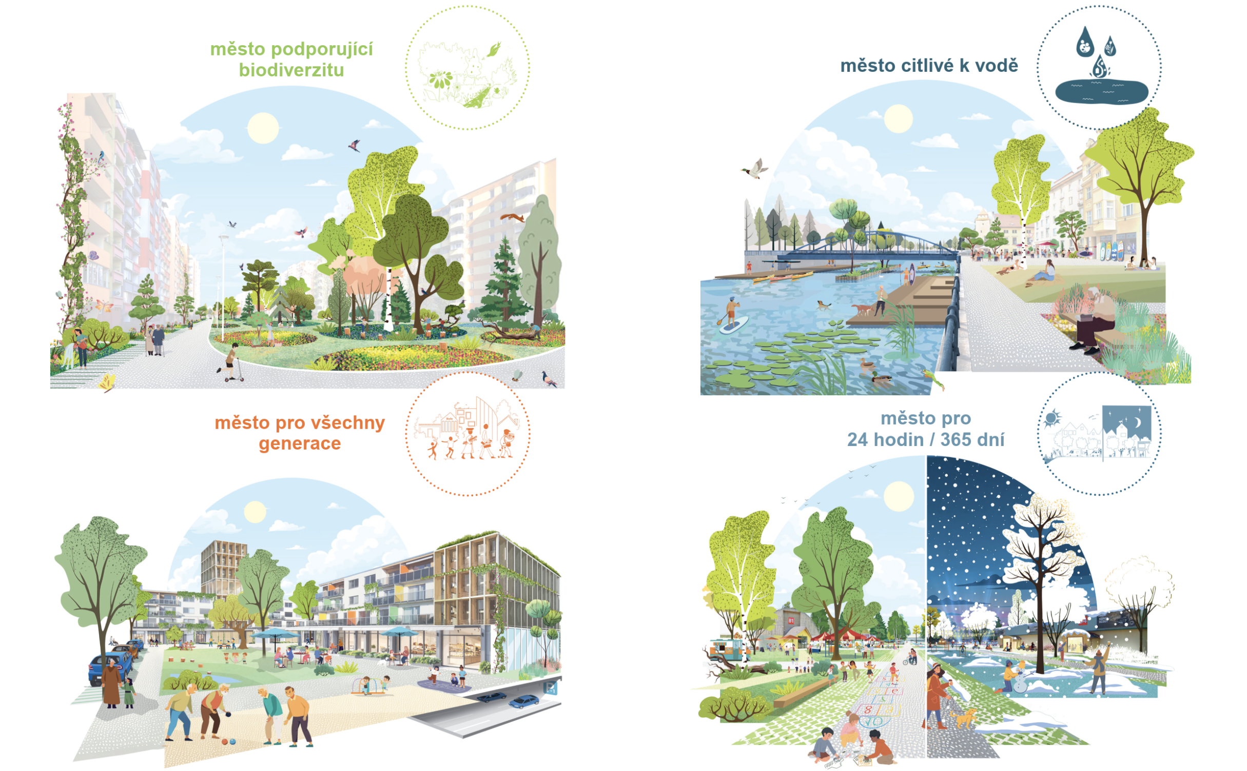
Nature must be an integral part of every neighborhood, not just the surrounding landscape. České Budějovice aims to increase the species diversity of its green spaces, which will strengthen their resilience to climate change, improve water retention, and reduce heat stress. In addition to more extensive planting, a change in maintenance is also key: a shift from intensive mowing to extensive care, which is cheaper and more environmentally beneficial.
A WATER-SENSITIVE CITY
Water forms the backbone of České Budějovice’s development. We propose strengthening its role in the city’s ecosystem by expanding water features and connecting them to the network of green spaces and slow transportation. Aesthetic and functional improvements to waterways will create an attractive environment for recreation and ecology, enhancing the quality of life in all neighborhoods.
A CITY FOR ALL GENERATIONS
České Budějovice strives for inclusivity through a diverse range of housing options that support intergenerational coexistence. Every neighborhood must offer accessible amenities (schools, jobs, social services) for all age groups. Minimizing single-use zones and ensuring the proximity of services will reduce dependence on cars, thereby protecting public spaces. A city designed for children and seniors is a city that works for everyone.
A CITY FOR 24 HOURS A DAY / 365 DAYS A YEAR
České Budějovice strives for inclusivity through a diverse range of housing options that promote intergenerational coexistence. Every neighborhood must offer accessible amenities (schools, jobs, social services) for all age groups. Minimizing single-use zones and ensuring the proximity of services will reduce dependence on cars, thereby protecting public spaces. A city designed for children and seniors is a city that works for everyone.
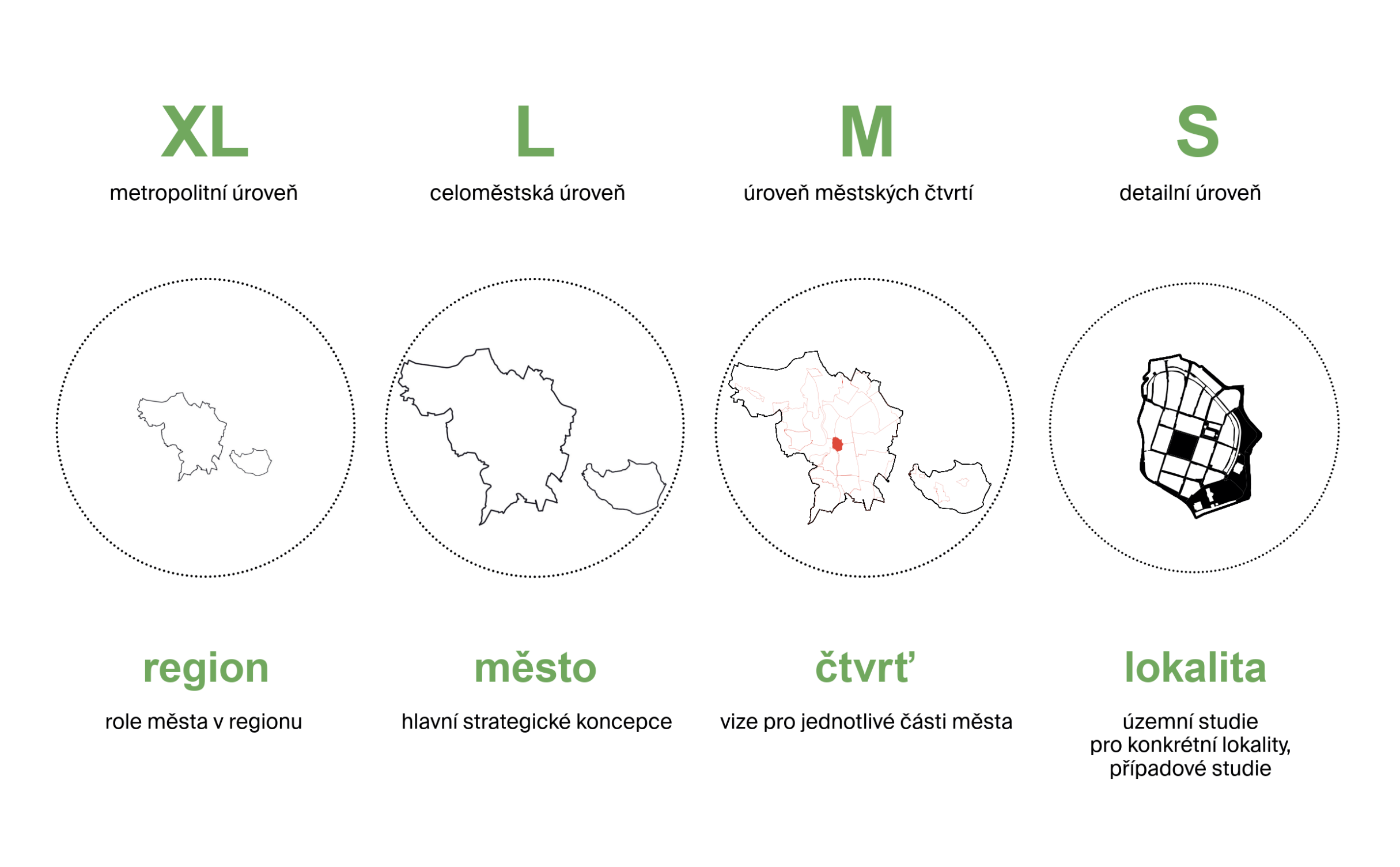
WORKING WITH DIFFERENT SCALES
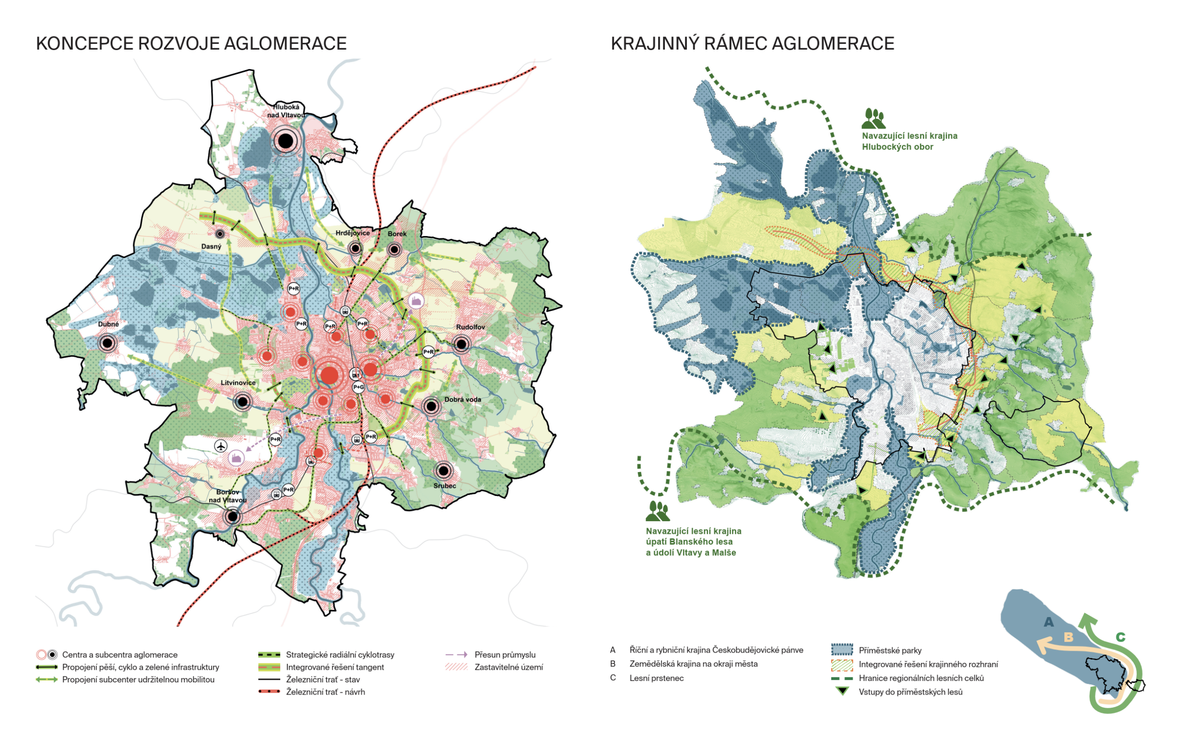
XL Metropolitan Level – The City’s Role in the Region
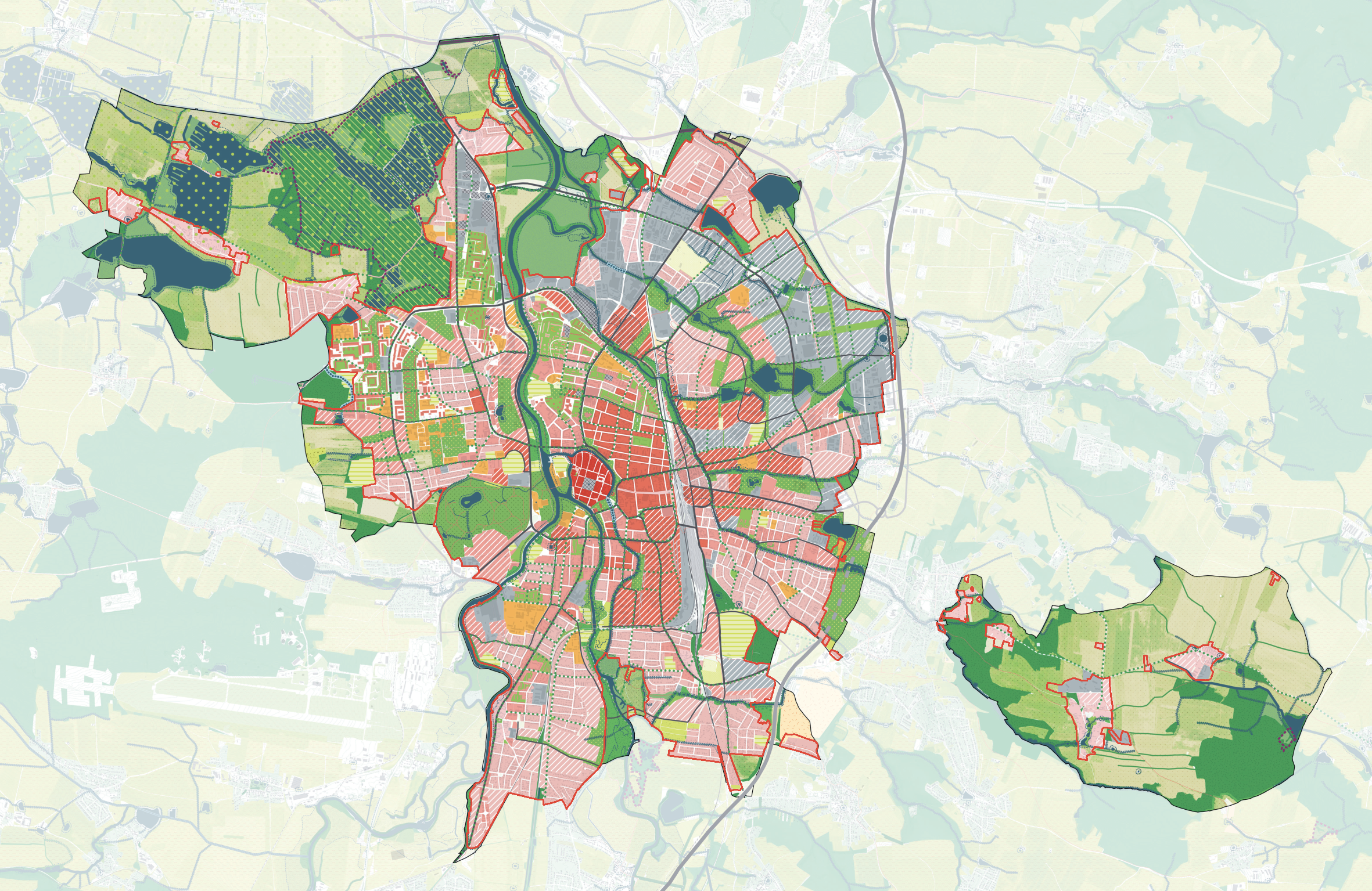
We are examining České Budějovice from the region’s perspective at the largest scale (eXtra Large). The draft zoning plan will take into account both the regional significance of České Budějovice and the connections between neighboring municipalities and the city of České Budějovice. České Budějovice is not an island but is interconnected with its surroundings.
L City-wide level – main strategic concepts
At the second scale level (Large), we formulate basic concepts that impact the development of the entire city; these have city-wide significance and extend across multiple neighborhoods. For example, in the case of the transportation concept, this involves the design of roadways, pedestrian, and bicycle connections passing through multiple neighborhoods; in the case of the landscape concept, it involves the design of green “wedges” extending into multiple neighborhoods, the design of recreational use of riverbanks, the design of transformation areas, etc.
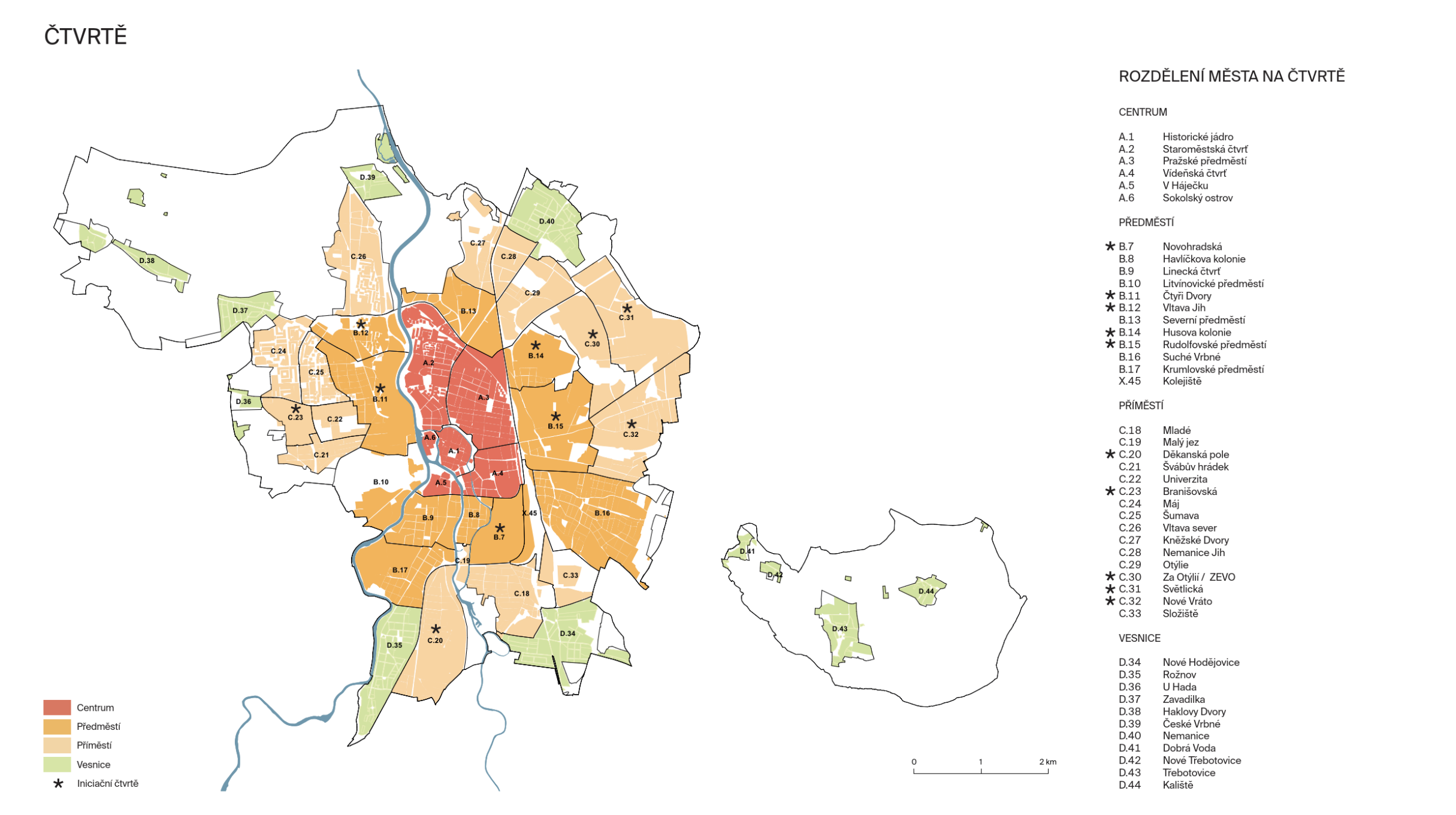
M Neighborhood Level – Visions for Individual Parts of the City
At the medium scale (Medium), we define individual neighborhoods by area, describing for each one its character, requirements for potential development, conditions for the spatial arrangement of buildings, etc. These neighborhoods take into account various characteristics that form the prerequisites for realizing the established ambitions.
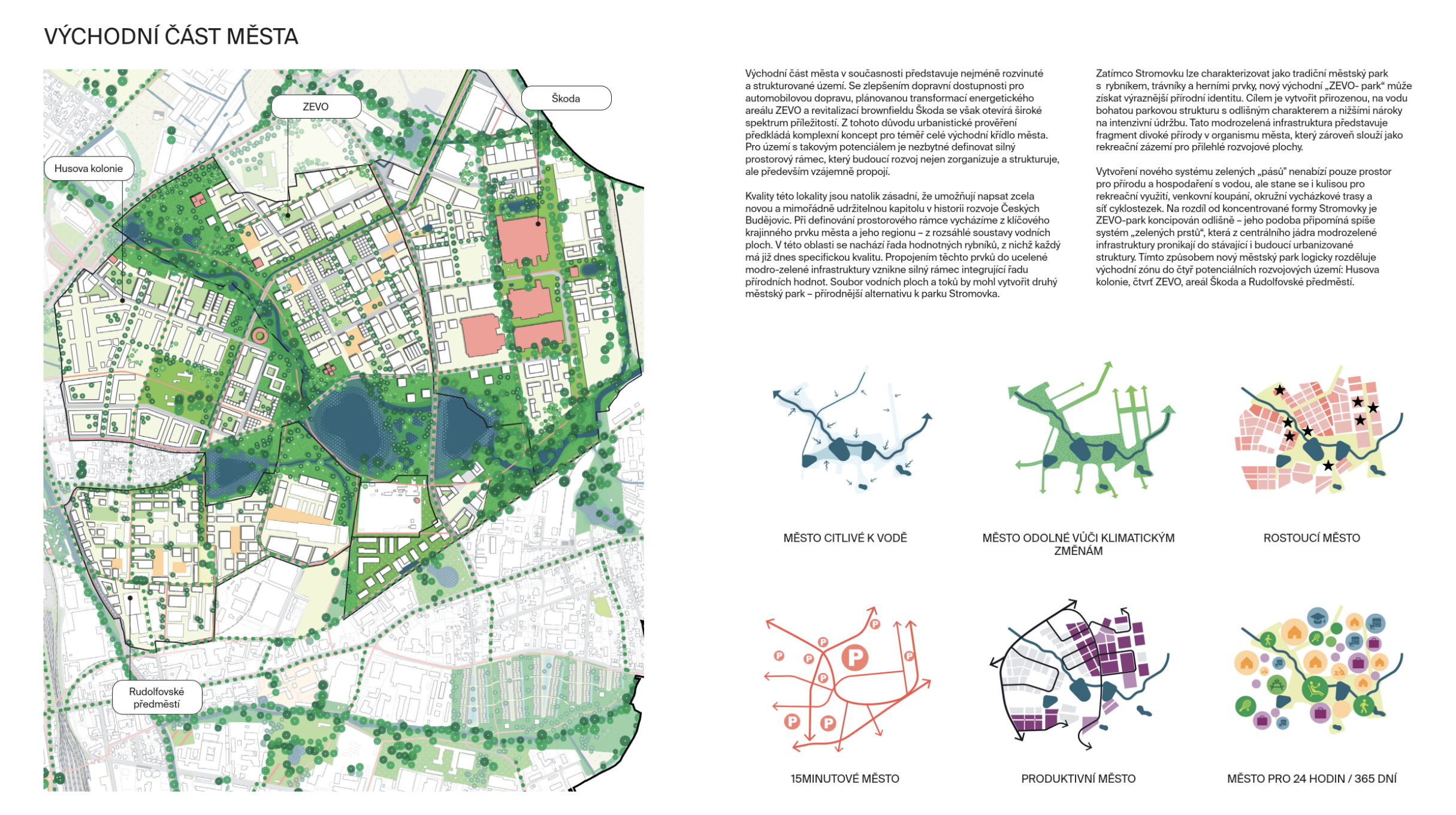
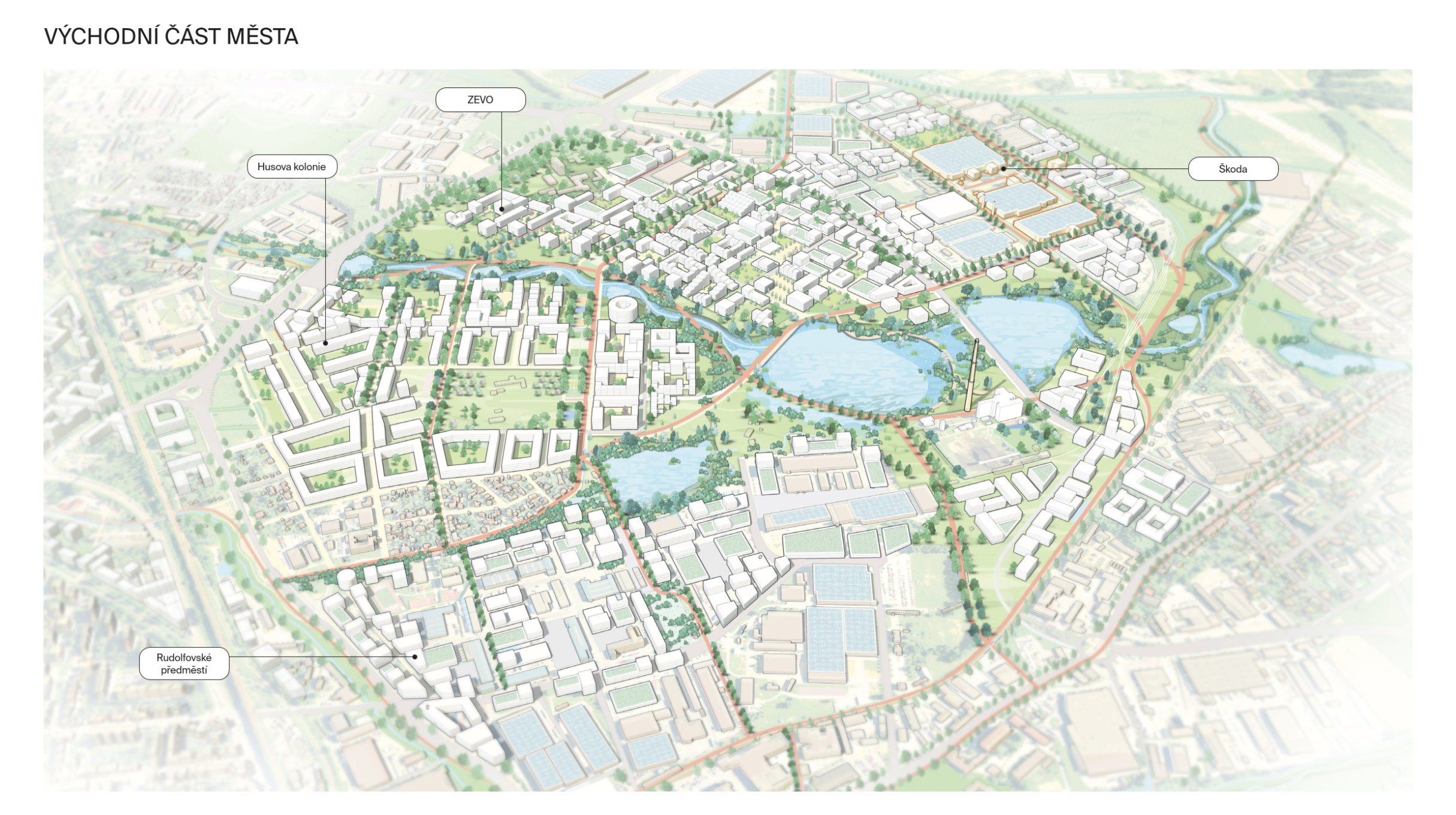
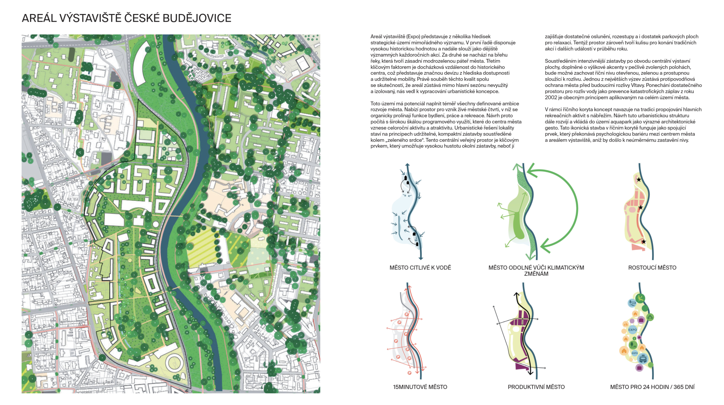
S Detailed Level – Regulatory Measures and Land-Use Studies for Specific Locations
At the smallest scale (Small), we define specific neighborhoods or parts thereof, transformation areas, or developable areas where, due to the need for detailed planning or to achieve a set ambition, it is necessary to require the preparation of a land-use study or a regulatory plan.
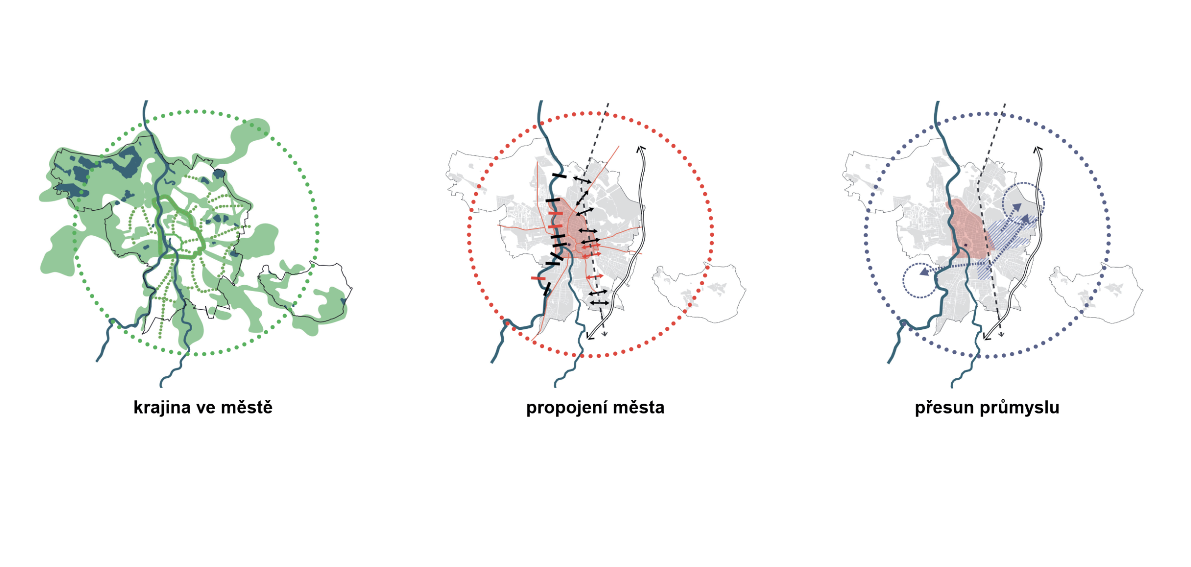
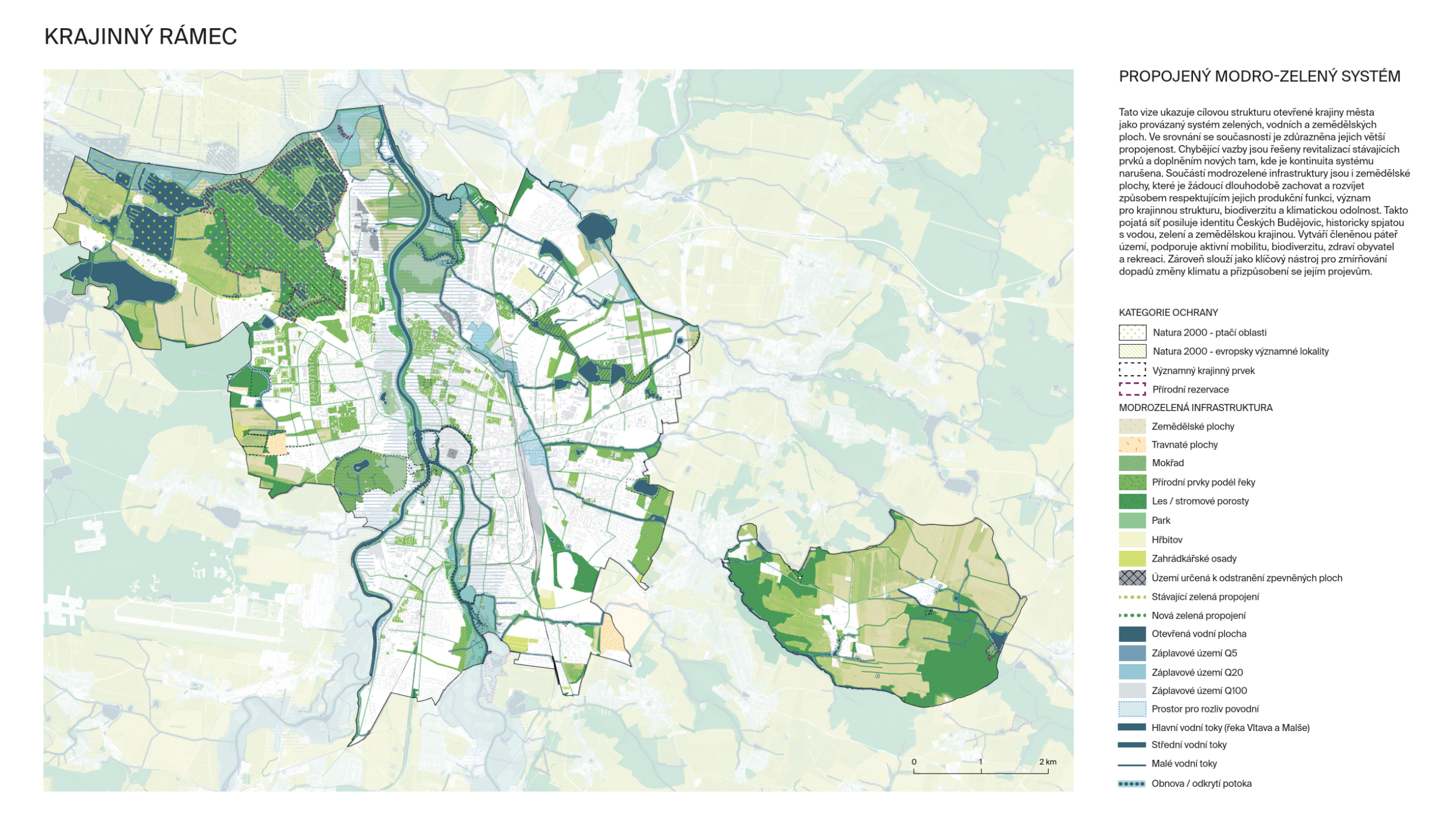
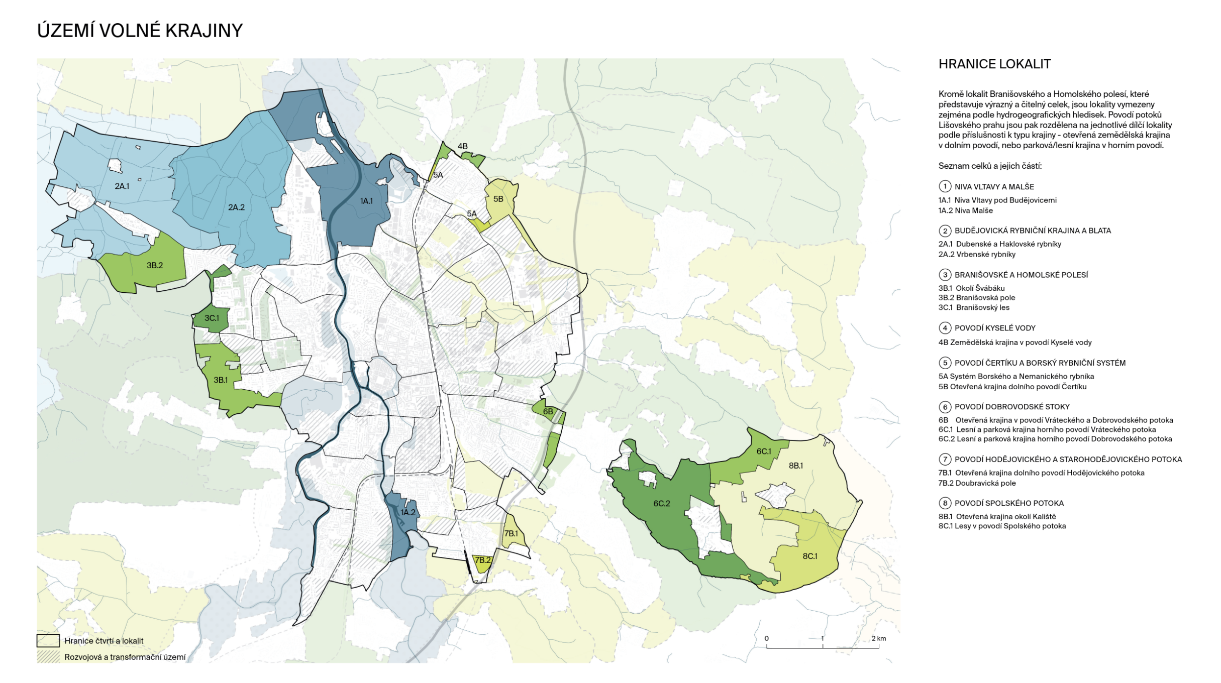
LANDSCAPE IN THE CITY
The landscape is an interconnected system that must be viewed as the fundamental framework influencing the quality of life in the city and its surroundings. The water regime, agricultural land, forests, ponds, and the floodplains of the Vltava and Malše rivers provide ecosystem services and recreational facilities, while strengthening the resilience and identity of the region. Their targeted enhancement and integration into development are key to sustainable growth.
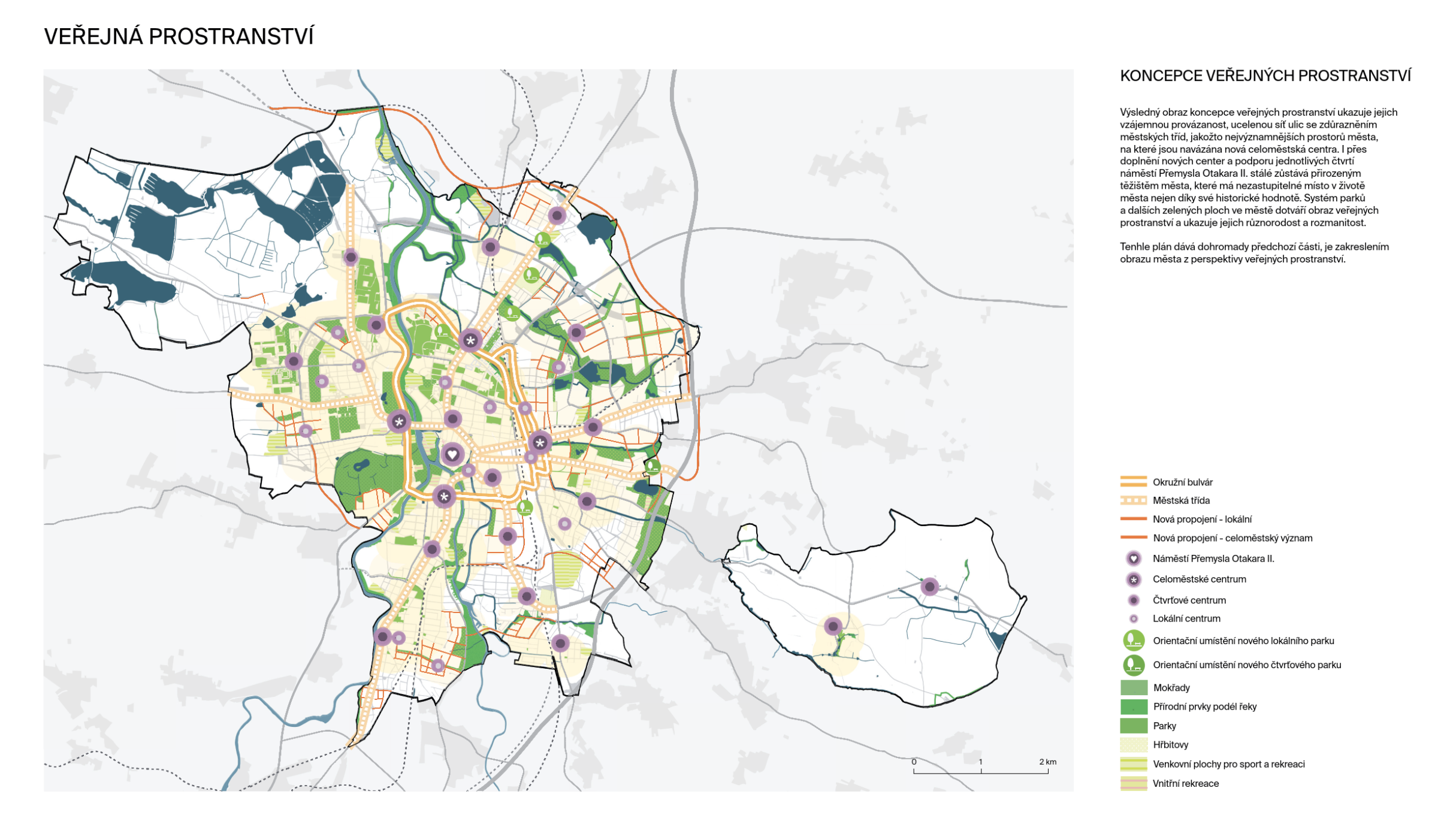
CONNECTING THE CITY
The goal is to connect the three parts of the city divided by the Vltava River and the railway: the western part on the left bank, the central part between the river and the railway, and the eastern part beyond the railway. We propose building on existing initiatives and adding new connections—bridges, footbridges, tunnels, or underpasses. These will not only improve mobility but also revitalize areas undergoing transformation and development.
INDUSTRIAL RELOCATION
20th-century industry was tied to water and rail; today, it is more flexible and oriented toward road transport. The city’s original factories have turned into brownfields with potential for transformation. Operational businesses can be relocated to new sites better suited to current needs; therefore, we propose areas for industry and logistics near the D3 highway in the north of the city and near the airport.
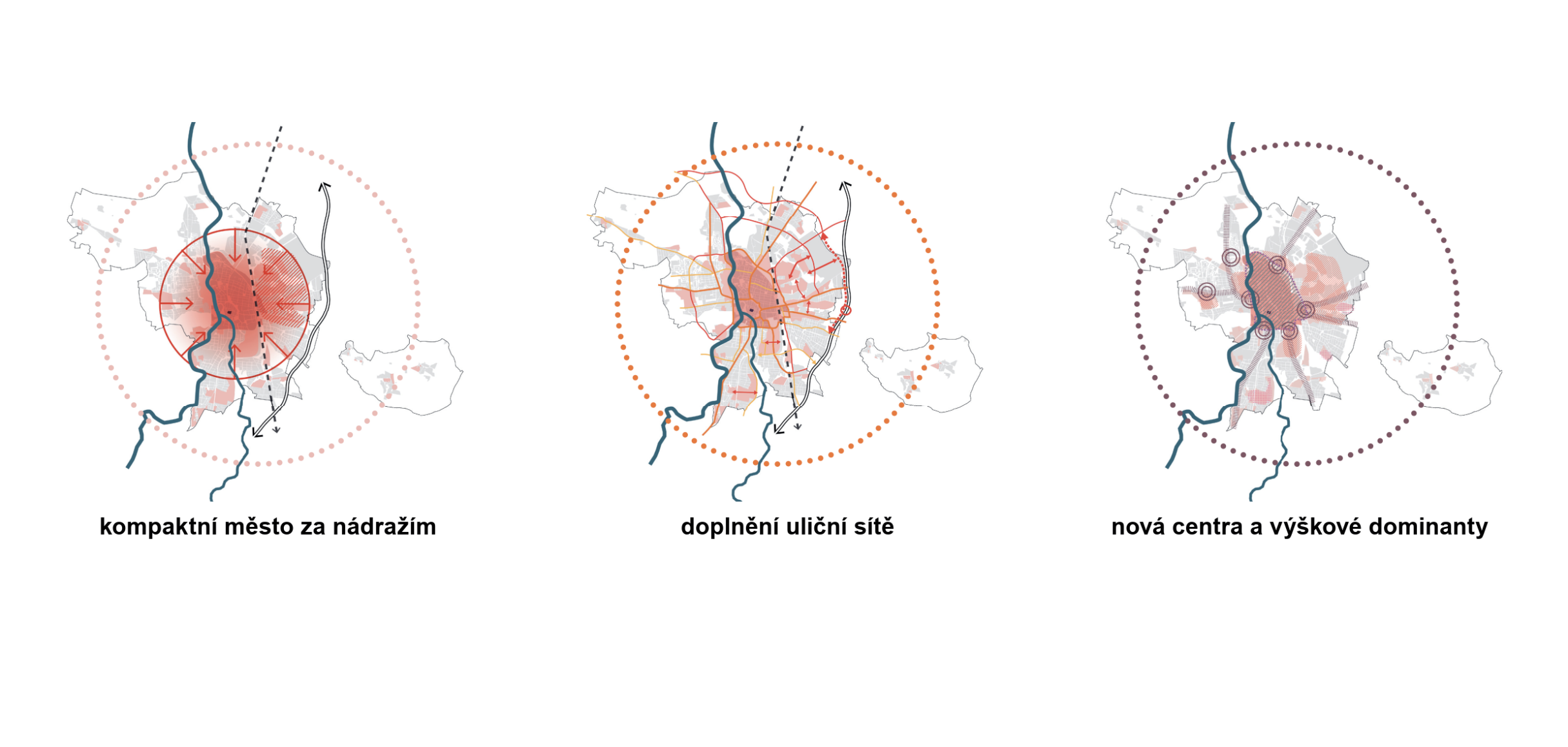
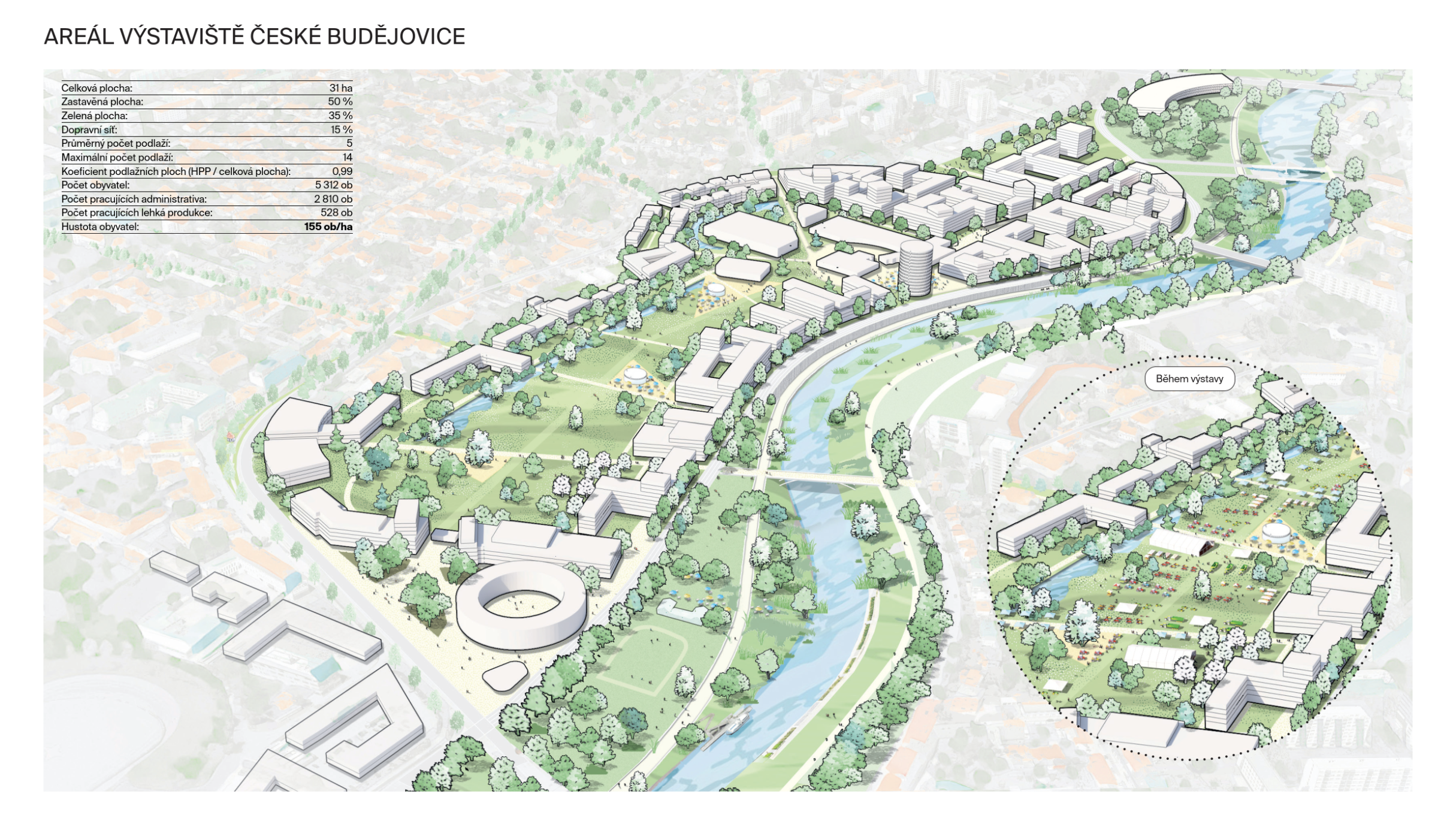
A COMPACT CITY BEYOND THE RAILWAY STATION
The transformation of brownfields behind the railway tracks into a vibrant urban neighborhood requires high population density. A critical minimum of 100 residents per hectare is necessary for the creation of a compact “city of short distances.” Higher values (200–250 residents per hectare) will then ensure even greater economic efficiency, sustainability, and urban vitality.
EXPANSION OF THE STREET NETWORK
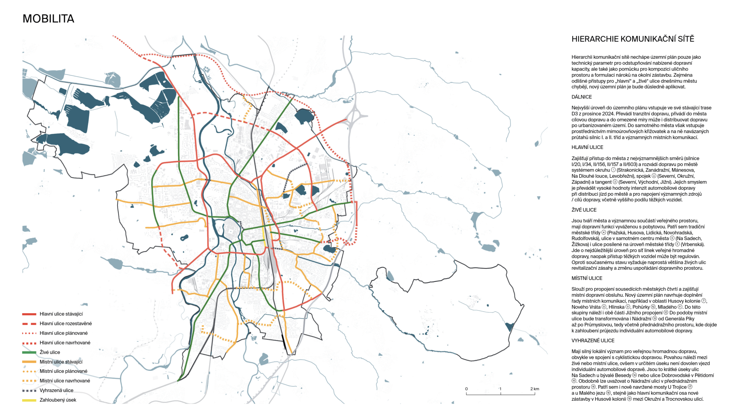
The foundation of a high-quality city is a network of vibrant and interconnected streets. In development areas, it is necessary to create a “city of short distances” structure with direct connections to existing neighborhoods. The goal is to transform boulevards into livable streets that support active mobility and are adapted to climate change.
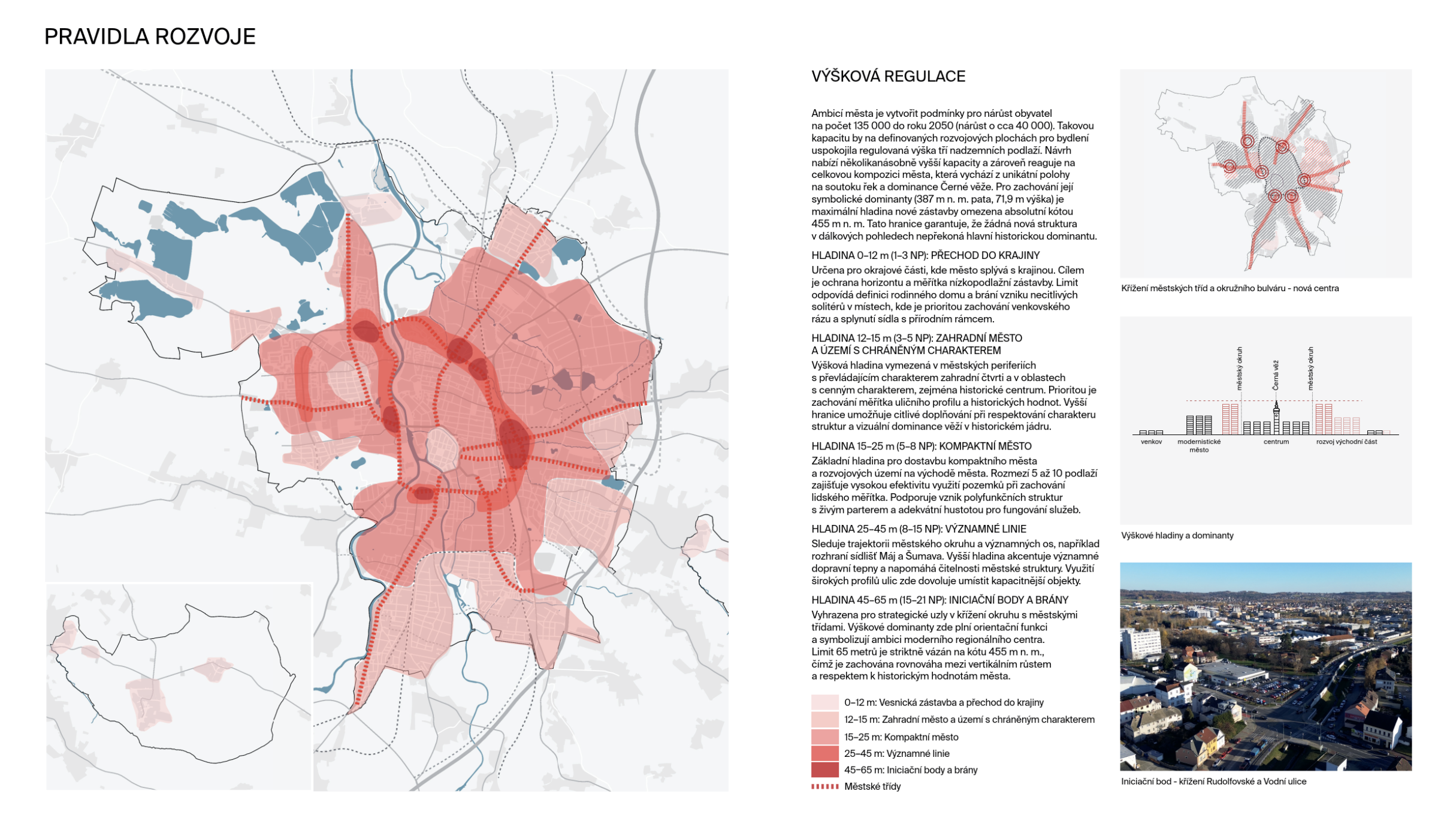
NEW CENTERS AND SKYSCRAPERS
At the intersections of city boulevards and the ring road, we propose the creation of local centers that will serve as “gateways to the city.” We define these locations as starting points for high-rise landmarks. We view city boulevards as key corridors suitable for taller development, for which we establish clear regulatory guidelines in these centers.